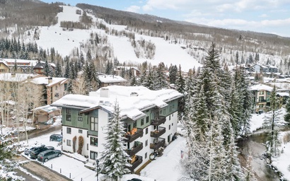
Steamboat Springs is known for its champagne powder in the winter, but do not sleep on its summers! The beauty in the summertime is entrancing magic that must be experienced.
One of the best ways to soak it all in starts at the trailhead! Steamboat is surrounded by National Forest and Wilderness Areas. We have lots of options from a short jaunt with the family, a couple of hours’ long hike, or a multi-day backpacking adventure. We have gathered our Top 5 Hikes in Steamboat Springs for all levels.
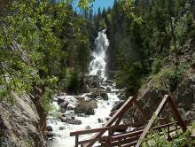
1. Fish Creek Falls/Long Lake
 Distance from Steamboat: 4 miles
Mileage: .5 miles round trip to lower falls, 5 miles round trip to upper falls, 12 miles round trip to Long Lake
Difficulty: Lower falls: easy; Upper falls and Long Lake: moderate to difficult
A trip to Steamboat is not complete without a Fish Creek Falls hike. The trail is accessible to all, with wheelchair and stroller access on the Overlook Trail. This paved trail leads to a birds eye view of the falls. Another option is a quarter-mile smooth gravel trail to the lower falls amidst the pine trees to a bridge. Watch the falls cascade from 280 feet above and crash down on the rocks below.
From here, you can continue on to reach the upper falls. This trail is considerably more rugged and steep as it heads up the forested canyon. Along the way, you are granted with views of the cascade and downtown Steamboat Springs. After 2.5 miles, you will reach the Upper Falls. Continue on to reach Long Lake. From here, the trail smooths out again and gradually climbs for 3 miles. Turn around and head back down the way you came. This is a very busy hike! For the best luck, start this early in the morning to avoid the traffic.
Find more details on All Trails for Fish Creek Falls and Long Lake Trails.
2. Uranium Mine
Distance from Steamboat: 4 miles
Mileage: 3.1 miles round trip
Difficulty: Moderate to difficult
This trail is a lot less crowded than Fish Creek Falls and shares the same parking lot. You can find the trailhead by heading back down the road and on your right. Start hiking a rocky path that switches back and forth up the canyon through dense mountain greenery. When you enter a basin surrounded by aspen trees, the trail ends at the uranium mine. This mine was built in the 1950s during the Cold War and was quickly abandoned. Head back down the way you came with canyon views all the way down.
3. Gilpin Lake

Distance from Steamboat: 31.2 miles
Mileage: 9 miles round trip
Difficulty: Moderate to difficult
If you’re worried about the drive to this hike – believe us, it’s worth it! Start this hike at the Slavonia Trailhead at the end of Seedhouse Road. This trail winds through thick forests of conifer trees, wildflower meadows, aspen groves and follows Gilpin Creek most of the way up to the lake. The apex of this hike is when you reach the spectacular blue waters of Gilpin Lake. Pack a lunch to enjoy when you reach the lake.
If you’re looking for something even more epic, this trail is part of the Zirkel Circle that continues to Gold Creek Lake and back down to the parking lot for the Slavonia Trailhead. The Zirkel Circle is 11 miles roundtrip.
4. Hot Springs Trail
Distance from Steamboat: 5.5 miles
Mileage: 5.7 miles round trip
Difficulty: Easy
Planning to hit the majestic Strawberry Park Hot Springs? Why not hike to it? Don’t forget to pack your bathing suits, towels and cash for your entry fee (and have a reservation for Summer 2021). You’ll find the trailhead at the Mad Creek Trailhead parking lot on Elk River Road. The Hot Springs Trail is marked FS #1169. Follow the narrow trail along the stream, pass through evergreen and aspen groves until you reach the end of the trail directly across from the main entrance to the hot springs. Pat yourself on the back, because you’ve earned this soak!
5. Rabbit Ears Peak
Distance from Steamboat: 22 miles
Mileage: 5.4 miles round trip
Difficulty: Moderate to difficult
If you reached Steamboat Springs by car, it is likely you drove over Rabbit Ears Pass, home of the “Rabbit Ears” rock formation. This hike will bring you right to the ears. The Rabbit Ears Peak trailhead is at the stone monument near Dumont Lake Campground. From here, the hike takes you to the 10,654-foot peak. It’s a rocky trail, involving some moderate climbing and a rock scramble for the last quarter mile. Much of this hike is exposed, so be sure to pack sunscreen and a hat.
This hike is particularly spectacular when wildflowers are in full bloom, typically in late June to early August.
Other Summer Activities
You’d have to stay all summer to sample all that Steamboat has to offer, but here are just a few of our guests’ favorite summer activities. Fly fishing, tubing the Yampa, strolling the botanical gardens, cruising the core trail, touring the craft beer breweries, mountain biking, road biking, paddle boarding at Pearl Lake, pontooning on Steamboat Lake, riding the Outlaw Mountain Coaster, hitting the links at Haymaker, picnicking at Spring Creek, walking along the river at the ski area, enjoying sunset happy hour at the top of the mountain, horseback riding, river rafting, zip lining, wakeboarding or just savoring Steamboat’s culinary creations outside by the river…